Hiking Lake McDonald Valley
Favorite Trails
Trail of the Cedars and Avalanche Lake
Although, as at Logan Pass, it is often difficult to find mid-day parking, this is another very doable two-option hike for families. The one mile loop of The Trail of the Cedars comes as a most pleasant surprise to travelers who have experienced just about everything in the rest of Glacier National Park. In this stunning oasis, just 5.5 miles east of Lake McDonald Lodge, it is almost shocking to find oneself transported to a virtual West Coast rainforest. Climatic conditions have fortuitously combined to make this the easternmost “island” of Cedar/Hemlock forest in the contiguous United States.
Before extensive fires and pre-Park logging in the late 19th and early 20th Centuries, these climatic conditions extended as far as West Glacier, but only this small area has survived to present times. Because it is unlikely that these ideal conditions will continue to exist beyond the 21st Century, the Trail provides a unique opportunity to study climate change in rapid transition.
Most of all, this walk provides an astounding opportunity to step out of the parking lot and into one of the most beautiful and peaceful forests that one could ever hope to visit. Halfway around the loop, just when it seems impossible to find more sensual joy in nature, the boardwalk crosses Avalanche Creek and looks up into Avalanche Gorge. Impressionist Painters would not attempt to convince viewers that so much color, varied texture and beauty could really be found in nature – no kidding!
If the Trail of the Cedars does not quite fill the bill, hikers can follow the gorge and creek up to Avalanche Lake. The round trip is a very gradual climb and descent of 4.2 miles. The view of the lake in a bowl of mountains is well worth the relatively easy hike. This destination is particularly rewarding early in the year when frequent, but safely distant, avalanches around the lake make it obvious where and why the lake got its name
Day Hikes
All mileages listed are ONE-WAY
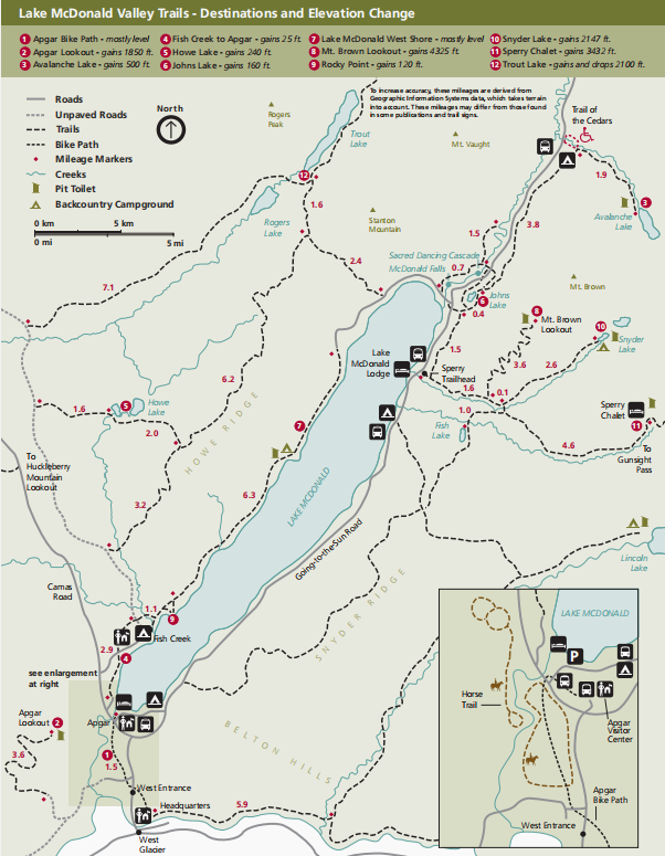
Apgar Bike Path
1.5 mi (2.4 km)
mostly level
Trailhead: Asphalt path south of Apgar Backcountry Permit Office
Apgar Lookout
3.6 mi (5.8 km)
Elevation gain: 1,850 ft (564 m)
Trailhead: Turn left 0.5 miles north of the West Entrance, continue 1.5 miles beyond Quarter Circle Bridge
Avalanche Lake
2.3 mi (3.7 km)
Elevation gain: 500 ft (152 m)
Trailhead: Avalanche Picnic Area
Fish Creek Bike Path
1.2 mi (1.9 km)
Elevation gain: 25 ft (7.6 m)
Trailhead: Turn right 0.25 miles north of the Lower McDonald Creek Bridge on the Camas Road
Fish Lake
2.7 mi (4.3 km)
Elevation gain: 1,000 ft (305 m)
Trailhead: Sperry Trailhead
Forest and Fire Nature Trail
1.1 mi loop (1.8 km)
Elevation gain: 180 ft (55 m)
Trailhead: Parking area off Camas Road near Camas Creek Entrance
Howe Lake
1.6 mi (2.6 km)
Elevation gain: 240 ft (73 m)
Trailhead: Howe Lake Trailhead on Inside North Fork Road
Huckleberry Lookout
6 mi (9.6 km)
Elevation gain: 2,725 ft (830.5 m)
Trailhead: Huckleberry Mtn. Trailhead on Camas Road
Johns Lake Loop
3 mi (4.8 km)
Elevation gain: 160 ft (49 m)
Trailhead: Johns Lake Trailhead
Lake McDonald West Shore
7.4 mi (11.9 km)
mostly level
Trailhead: [a] 0.2 miles north of Fish Creek Campground; [b] 2.8 miles west on North Lake McDonald Road
Lincoln Lake
8 mi (12.9 km)
Elevation change: gains 2,250 ft (686 m) and drops 800 ft (244 m)
Trailhead: Lincoln Lake parking area, off Going-to-the-Sun Road between Apgar and Lake McDonald Lodge
Mt. Brown Lookout
5.2 mi (8.4 km)
Elevation gain: 4,325 ft (1,318 m)
Trailhead: Sperry Trailhead
Oxbow Trail
1.5 mi (2.4 km)
mostly level
Trailhead: South side of Lower McDonald Creek Bridge on Camas Road
Rocky Point
1.1 mi (1.8 km)
Elevation gain: 85 ft (26 m)
Trailhead: 0.2 miles north of Fish Creek Campground
Snyder Lakes
4.3 mi (6.9 km)
Elevation gain: 2,147 ft (654 m)
Trailhead: Sperry Trailhead
Sperry Chalet
6.3 mi (10.1 km)
Elevation gain: 3,432 ft (1,046 m)
Trailhead: Sperry Trailhead
Trail of the Cedars
0.7 mi (1.1 km)
Accessible
Trailhead: Avalanche Picnic Area
Trout Lake
4 mi (6.4 km)
Elevation change: gains and drops 2,100 ft (640 m)
Trailhead: Trout Lake Trailhead